
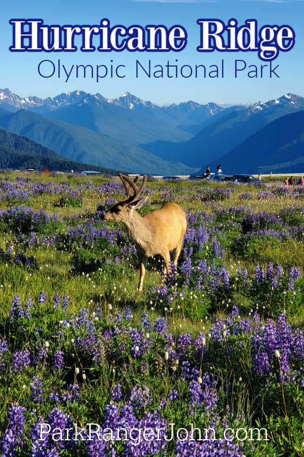
Hurricane Ridge in Olympic National Park is named for the gusting hurricane-like winds that can be experienced.
TL;DR Don't have time to read the full article? Here are my top finds:
🏨Hotels and Vacation Rentals
📍Tours
🐻 Save time! Buy your National Park Pass before your trip
Hurricane Ridge - Olympic National Park
It is not uncommon for the area to get 30 to 35 feet of snow each winter. You can still experience snow all the way into the summer.
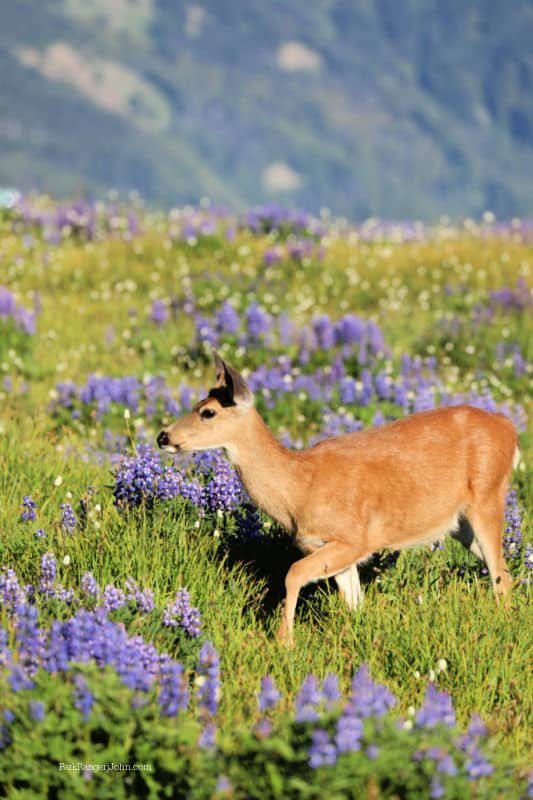
The drive up to Hurricane Ridge is gorgeous and slightly unnerving if you are not used to driving mountain roads. Don't worry it is a paved road to the top but you will want to keep an eye out for wildlife.
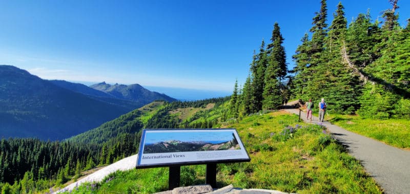
One of the best things about the Hurricane Ridge mountain area is the magnificent panoramic views of the park. The views of Olympic National Park and the surrounding area are breathtaking!
On a clear day, you can see Canada and so much more!
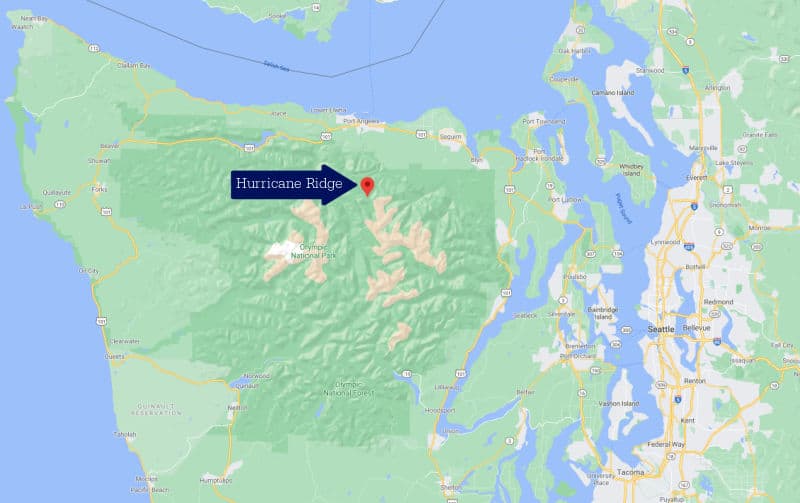
Where is Hurricane Ridge?
Hurricane Ridge is part of Olympic National Park in Washington State. The closest city is Port Angeles located at the base of the mountain.
It is approximately a 45-minute drive from Port Angeles to Hurricane Ridge. There is a National Park Service entrance station at the base of the hill that can get backed up and cause delays.
How to get to Hurricane Ridge from Seattle?
From Seattle, you have a couple of options to reach Hurricane Ridge and Olympic National Park. You can take the Seattle - Bainbridge Ferry across Puget Sound and then drive past Poulsbo and around the peninsula to reach Port Angeles and head up to Hurricane Ridge.
The other option is to drive south on I-5 to Tacoma and cross the Tacoma Narrows Bridge on Highway 16 and continuing until you reach Highway 3 and then drive around the peninsula to Port Angeles and up to Hurricane Ridge.
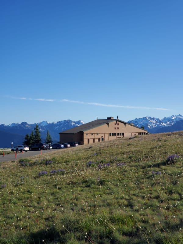
Hurricane Ridge Visitor Center
Unfortunately the Hurricane Ridge Visitor Center burned on May 8, 2023 and is unrepairable at this time.
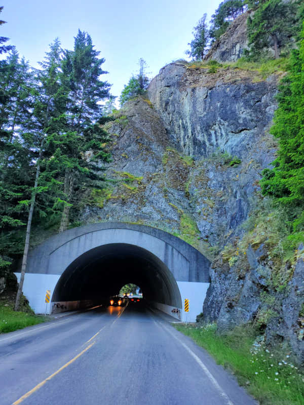
Hurricane Ridge Road
Open 24 hours a day from mid-May into October.
The rest of the year it opens (weather permitting) primarily on weekends.
Call 360-565-3131 for a 24- hour road and weather recording. It is really important to call for updates especially in winter, spring, and fall. You never know when the road will be closed due to snow.
The park service does a great job clearing the road but there can be delays and closures due to weather.
Hurricane Ridge Camping
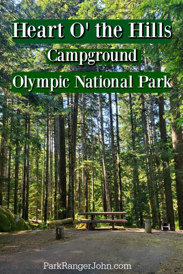
Heart O' the Hills Campground
The closest vehicle campground is at Heart O' the Hills, 12 miles downhill from the top of Hurricane Ridge.
Heart O' the Hills Campground has 105 campsites that are first come first serve. This campground is incredibly popular!!! You will want to get to the campground early in the day to find a campsite.
Wilderness Camping
Get wilderness camping permits at the Wilderness Information Center, 360-565-3100, in Port Angeles.
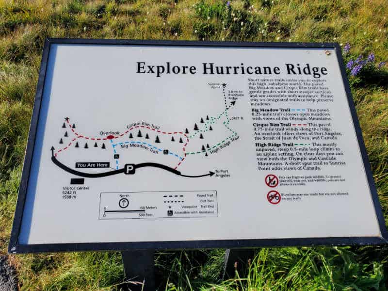
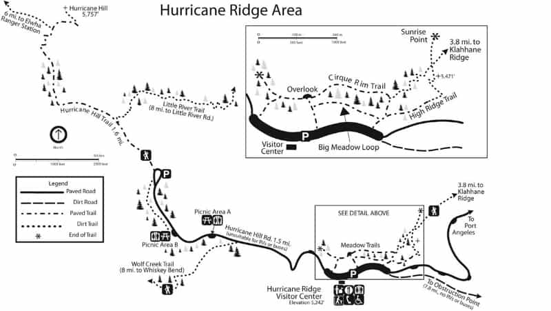
Hurricane Ridge Hiking Trails
Cirque Rim
Distance - 0.5 miles one way
Elevation Gain - Under 50 feet
Big Meadow
Distance - 0.5 miles one way
Elevation Gain - Under 50 feet
High Ridge
Distance - 0.5 mile loop
Elevation Gain - +220 ft.
Klahhane Ridge
Distance - 3.8 miles one way
Elevation Gain - +250 ft. first 2.8 miles
Hurricane Hill
Distance - 1.6 miles one way
Elevation Gain - +700 ft.
Wolf Creek
Distance - 8.0 miles one way
Elevation Gain - -3,772 ft
Little River
Distance - 8.0 miles one way
Elevation Gain - -4,073 ft.
Hurricane Hill/Elwha
Distance - 6.0 miles one way
Elevation Gain - -5,250 ft
Hurricane Ridge in the Winter
During the winter Hurricane Ridge is the place to go for snowshoeing, cross country skiing, snowboarding, and tubing along with downhill skiing in Olympic National Park. The average snowfall on the ridge is over 400 inches of snow!
The winter season normally runs from mid-December through the end of March depending on the snow each year.
During the winter months Hurricane Ridge Road is typically open to uphill traffic from 9:00 am to 4:00 pm, Friday through Sunday, and some holidays, weather and road conditions permitting.
Depending on road conditions the times can vary significantly.
Road and weather condition updates are available on the Road and Weather Hotline at (360) 565-3131 or by following @HRWinterAccess on Twitter.
All vehicles are required to carry tire chains and must be below the Heart O' the Hills entrance station by 5:00 pm during the winter season. This requirement applies to all vehicles (including 4-wheel drive), regardless of tire type or weather conditions.
Hurricane Ridge has 15 to 20 miles of snowshoeing and cross-country skiing trails each winter. None of the trails are marked or groomed.
The Hurricane Ridge Ski, Snowboard & Tubing Area is a small, family-oriented ski area operated by the Hurricane Ridge Winter Sports Club.
The ski area includes two rope tows, a Poma lift, and a tubing park. The ski area is generally open from mid-December through the last Sunday in March, weather permitting.
It is interesting to know that this is one of only 2 lift operations running within the National Parks.
One really important thing to know about visiting Hurricane Ridge in the winter is there are only 175 parking spots plowed at the top. To ensure you get a parking space and don't have to wait at the bottom for a space to open we highly recommend getting to the entrance station by 8 am.
Hurricane Ridge Elevation
5,242 feet in elevation
Hurricane Ridge Map
Distance to other Olympic National Park Destinations
One thing to know about traveling within Olympic National Park is many destinations are a fair distance away from each other. This is not a park you are going to see everything in one or two days.
It can take a lot longer than you expect to reach many destinations within the park. Plan extra time for driving!
Hurricane Ridge to -
Crescent Lake -Storm King Ranger Station - 39 miles, 1 hour
Sol Duc - 59 miles, 2 hours
Hoh Rainforest - 106 miles, 2 hours 45 minutes
Kalaloch - 109 miles, 2 hours 30 minutes
Mora - 85 miles, 2 hours 15 minutes
Lake Ozette - 93 miles, 2 hours 45 minutes
Lake Quinault- 143 miles, 3 hours 15 minutes
Staircase Ranger Station - 120 miles, 2 hours 45 minutes
Rules/Regulations
Pets and bicycles are not permitted on paved or dirt trails.
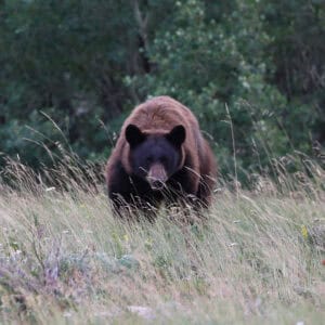
Do not feed wildlife.
Additional Olympic National Park Information & Resources
Where to stay when visiting Olympic National Park
Olympic National Park Lodging
There are multiple National Park Lodges within the park. Deciding on which lodge to stay in will largely depend on what part of the park you plan to explore because it certainly is one of those National Parks that you'll visit multiple times and still have something new to see (like we do!)
🏨Ready to Book the Kalaloch Lodge -> Click Here
- Season: Year-round
- Location: Along Highway 101 on the Pacific Ocean
The Kalaloch Lodge is a perfect place to stay while exploring the Olympic Peninsula and was indeed one of our favorite National Park Lodges we've ever stayed at. With well-equipped rooms and unbeatable views of Kalaloch Beach, you're sure to fall in love with this lodge.
🏨Ready to Book Sol Duc Hot Springs Resort -> Click Here
- Season: Mid-April to the end of October
- Location: Right by the Sol Duc Hot Springs
The Sol Duc Hot Springs Resort is a rustic, serene property located by the hot springs. With a reservation at this resort, you'll also get access to swim in the hot springs, which was undoubtedly the highlight of our stay there. The property's prime location in the forested region also gives you easy access to the nearby trails, the Sol Duc Falls, River, and Valley.
🏨Ready to Book the Lake Crescent Lodge -> Click Here
- Season: May to January
- Location: Beside Lake Crescent, approximately 30 minutes from Port Angeles, Washington
The Lake Crescent Lodge boasts phenomenal views of Lake Crescent and offers a variety of accommodating options like cottages, lodge rooms, single tavern cottages, and more for you to choose from. If you end up deciding on a cottage (like we did), you'll get a chance to catch the gorgeous sunsets over the lake from your front porch. You can also rent kayaks from the property to go kayaking on the lake.
Lodging near Olympic NP
Olympic NP borders multiple gateway communities including Port Angeles, Sequim, Port Townsend, La Push, Olympia, Forks, and Shelton.
🏨Ready to Book the Lake Quinault Lodge -> Click Here
At Lake Quinault Lodge, you can look forward to golfing on site, a terrace, and shopping on site. For some rest and relaxation, visit the sauna. The onsite family restaurant, Roosevelt Room, features American cuisine. In addition to a firepit and mini golf, guests can connect to free in-room Wi-Fi.
Perch Small - Treehouse - Eagles Perch Over The Water
🏨Ready to Book Perch Small- Treehouse - Eagles Perch Over The Water -> Click Here
Stunning Tree house looking over the Strait of Juan De Fuca is a total North-West Washington experience. It is made of cedar with rustic touches. Once you are inside you will never want to leave as the floor to ceiling window looks onto the straight and with constant moving landscape of cruise ships, wildlife, and bald eagles soaring across your window.
Red Lion Hotel Port Angeles Harbor
🏨Ready to Book the Red Lion Hotel Port Angeles Harbor -> Click Here
Take advantage of dry cleaning/laundry services, a fireplace in the lobby, and a bar at Red Lion Hotel Port Angeles Harbor. This hotel is a great place to bask in the sun with a beachfront location. Be sure to enjoy a meal at 48° North, the onsite restaurant. Free in-room Wi-Fi is available to all guests, along with a gym and a business center.
Click on the map below to see additional hotel and vacation rental rates in the area.
Olympic National Park Guided Tours
Hoh Rain Forest and Rialto Beach Guided Tour in Olympic National Park
⭐️ Rating: 5 out of 5 Stars | ⏳ Tour Length: 9 hours | 🚌Check Rates and Availability
The ancient forests, mountains, and rugged beaches of the Olympic National Park provide some spectacular hiking opportunities. On this tour, visit two of the most stunning natural spots - Hoh Rainforest and Rialto Beach - and enjoy short hikes at both destinations. With round-trip transportation, National Park fees included, and an optional packed lunch, everything is taken care of, so you can focus on admiring the views.
Best of Olympic National Park from Seattle: All-Inclusive Small-Group Day Tour
⭐️ Rating: 4.9 out of 5 Stars | ⏳ Tour Length: 12 hours | 🚌Check Rates and Availability
Have a special chance to explore Olympic National Park with a naturalist guide - and make your sightseeing logistics smooth and hassle-free on this small group tour from Seattle. With round-trip transit from your downtown hotel, getting to the UNESCO-listed park is made simple. From beaches to mountains to forests and beyond, experience the best of this spectacular landscape, seeing and doing more with your guide than you could alone.
Self-Guided Audio Driving Tour in Olympic National Park
⭐️ Rating: 4.4 out of 5 Stars | ⏳ Tour Length: 8 hours to 1 day | 🔊Check Rates and Availability
Download this audio tour and you'll discover more on your Olympic National Park road trip. Hear fascinating behind-the-scenes stories, local tips, and directions play automatically, all based on your location.
You'll be guided to all of the park's famous highlights as well as the lesser-known gems, including the most easily accessed mountain area in the park with superb views and hiking trails, a unique temperate rainforest where you can walk amongst the giant trees, and incredible beaches rich with tidepools.
Olympic National Park Entrance Fee
Park entrance fees are separate from camping and lodging fees.
Park Entrance Pass - $30.00 Per private vehicle (valid for 1-7 days from the date of purchase)
Park Entrance Pass - Motorcycle - $25.00 Per motorcycle (valid for 1-7 days from the date of purchase)
Per-Person Entrance Pass - $15.00 Visitors 16 years or older who enter on foot, bicycle, or as part of an organized group not involved in a commercial tour.
Annual Park Entrance Pass - $55.00, Admits pass holder and all passengers in a non-commercial vehicle. Valid for one year from the month of purchase.
$75.00 for Commercial Van with 7-15 seats
$100.00 for Commercial Mini-Bus with 16-25 seats
$200.00 for Commercial Motor Coach with 26+ seats
Learn more about National Park Passes for parks that have an entrance fee.
$80.00 - For the America the Beautiful/National Park Pass. The pass covers entrance fees to all US National Park Sites and over 2,000 Federal Recreation Fee Sites for an entire year and covers everyone in the car for per-vehicle sites and up to 4 adults for per-person sites.
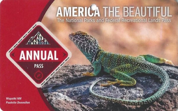
Buy your pass at this link, and REI will donate 10% of pass proceeds to the National Forest Foundation, National Park Foundation, and the U.S. Endowment for Forestry & Communities.
National Park Free Entrance Days -Mark your calendars with the free entrance days the National Park Service offers for US citizens and residents.
Additional Olympic National Park Resources
Check out all of the Olympic National Park Camping options. There are 14 campgrounds within the park
Olympic National Park Lodging - Check out our complete guide of all the places to stay within the park
Things to do in Olympic NP - Find out all of the top things to do in this great park.
Free National Park Days - Check out the 5 days a year the National Park Service waives entrance fees.
Most visited National Parks - Check out all of the top-visited parks in the United States
Moon Olympic Peninsula Guide Book
Olympic National Park trails map
Check out all of the Washington National Parks along with neighboring Oregon National Parks, Idaho National Parks, National Parks in Hawaii, and National Parks in Alaska
Make sure to follow Park Ranger John on Facebook, Instagram, Pinterest, and TikTok

Leave a Reply