
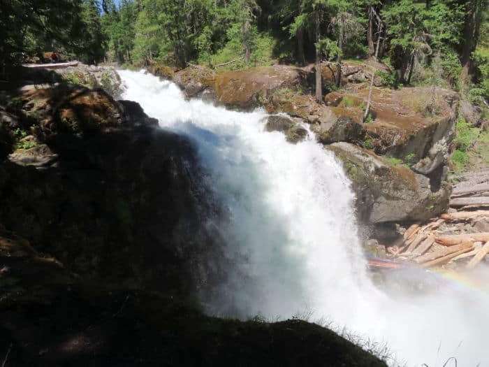
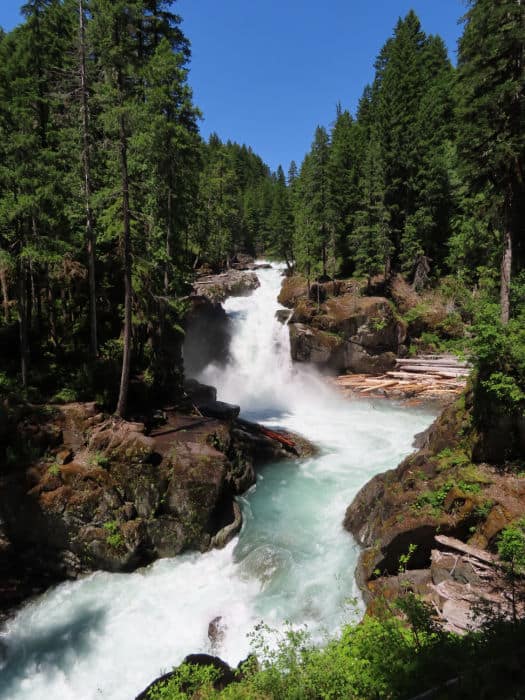
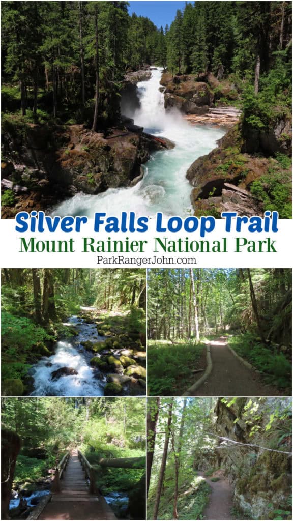
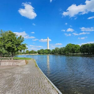
The Silver Falls Loop Trail is an epic hike that takes you to the beautiful Silver Falls in the Ohanapecosh area of Mt. Rainier National Park, Washington.
TL;DR Don't have time to read the full article? Here are my top finds:
🏨Hotels and Vacation Rentals
📍Tours
🐻 Save time! Buy your National Park Pass before your trip
Silver Falls Loop Trail - Mount Rainier National Park
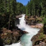
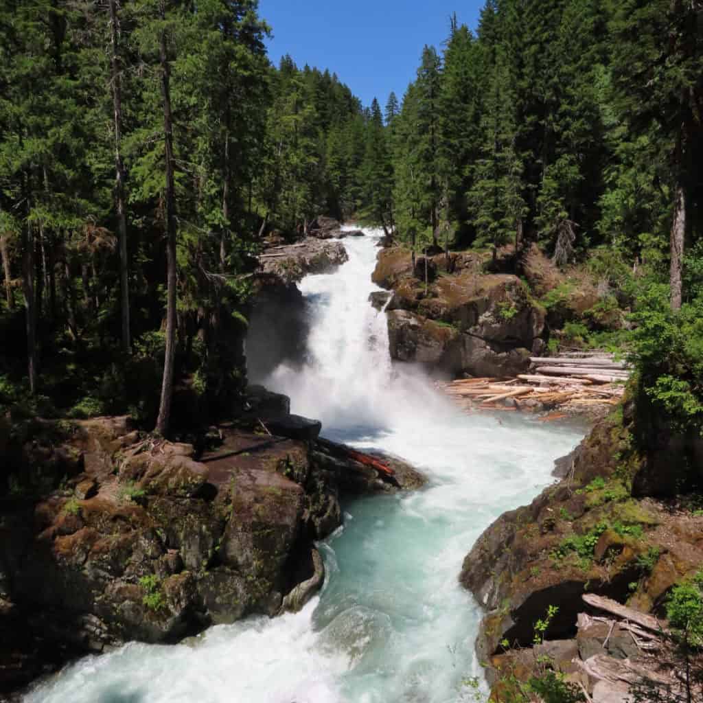
The views of Silver Falls are amazing, especially during June when the water level is high due to snowmelt.
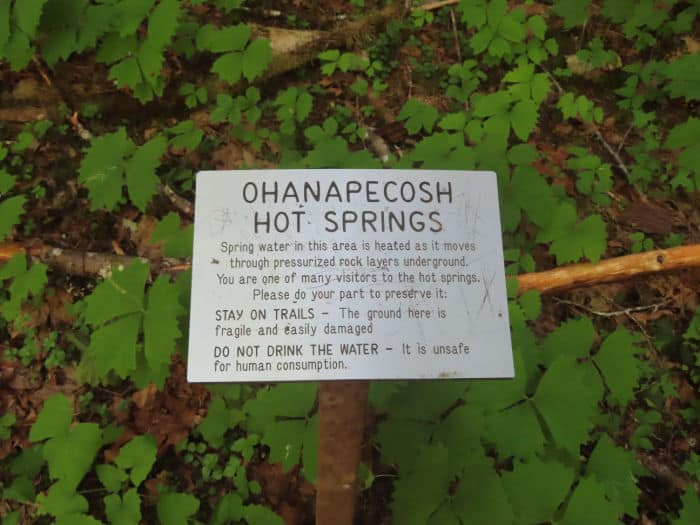
This trail has the fun factor as there are several stops along the hike like the Ohanapecosh hot springs and crosses the Ohanapecosh River with a few bridges.
It is also very cool how many families make this hike together. If you need information or daily updates on the park, there is an Ohanapecosh Visitor Center before the trailhead.
I highly recommend this hike for someone looking to get adventurous and make some memories. It is one of our favorite Mt Rainier Hikes.
Where is Silver Falls Loop Trail?
If you are coming from the west, towards or from Packwood, Get on or continue on US Highway 12 towards the East. From Packwood continue East on US Highway 12 for about 8 miles then turn left onto Highway 123 then continue for about 3 miles until you see the sign for the Ohanapecosh Campground. Then turn left.
Coming from Yakima, travel on US Highway 12 West for about 67 miles. Then turn right on to State Route 123 and continue for about 3 miles. Then turn left into the Ohanapecosh Campground.
Hiking Silver Falls Loop Trail
Distance: 1.5 miles each way, 3.0 miles round trip, loop hike
Elevation Gain/Loss: Gain of 600 feet
Average Hiking Time: 90 minutes to 3 hours depending on the hiker's ability and photography choices.
Trail Difficulty: Medium, may be difficult for people with knee or back problems or other health conditions.
Restrooms Available at Trailhead: The Ohanapecosh campground and Visitor Center where the trailhead is does have restrooms.
ADA Accessibility: This trail is not ADA accessible
Pets Allowed?: Pets are not allowed on this trail or on any of the trails in Mt. Rainier National Park
Parking Area: There is a small parking lot at the trailhead in the Ohanapecosh Campground by the visitor Center. A second option is parking at the Grove of the Patriarchs Trail. To find the trail just cross Stevens Canyon Road and look for the trail leading into the forest. You will be on the East Side Trail, just follow for a ½ mile to get to the Silver Falls loop trail.
Best time to hike this trail: The best time to hike the Silver Falls Trail is between May and September when the snow is clear of the trail.
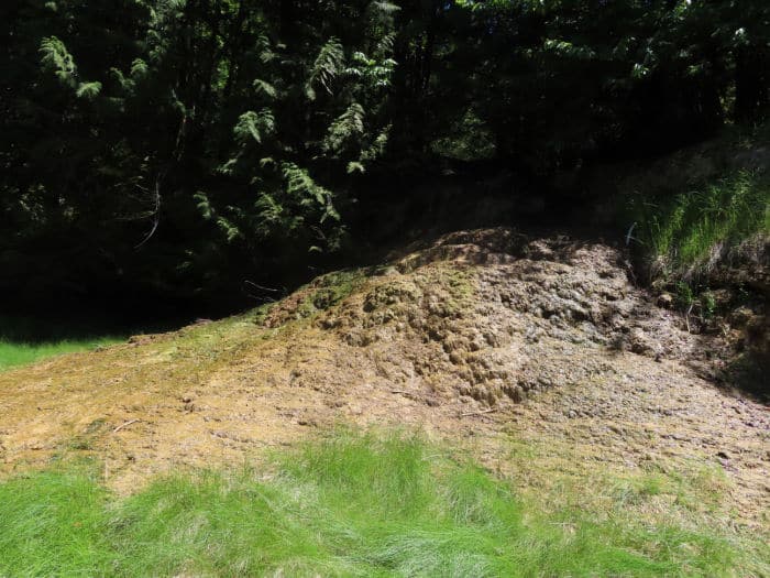
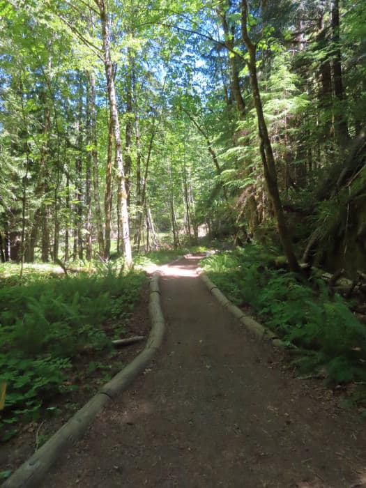
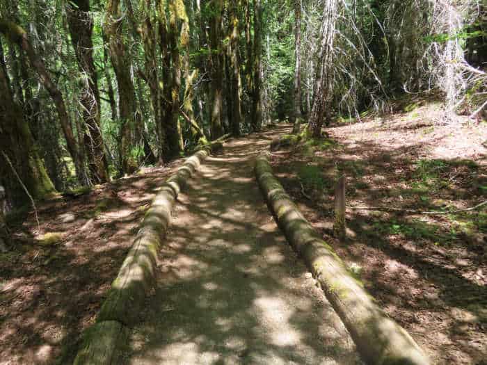
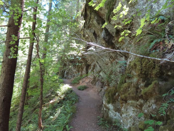
The first 1/10 mile is a self-guided interpretative trail with interpretative signs explaining Mount Rainier's ecosystem. A short distance afterward, the trail runs through a thermal area.
The first half of this trail is also slightly uphill most of the way but not too strenuous. This means the second half is downhill making for an easy second-half hike.
This trail has several places where the trail crosses a bridge to walk over streams feeding into the Ohanapecosh River. Several of these bridges make great photo opportunities!
There will be a fork in the trail when you get close to Silver Falls, make sure to take the trail to the right to the falls. If you accidentally take a left, you will end up on the Eastside trail and find yourself at the Grove of the Patriarchs Trailhead.
There are different distances depending on if you finish the whole loop or if you just travel to the falls and back. The whole loop is around 2.5 miles.
If you start from one side nearest to the ranger station it will be 1.1 miles to the falls. Leaving from the other trailhead on the other side of the bridge will be about 1.4 miles.
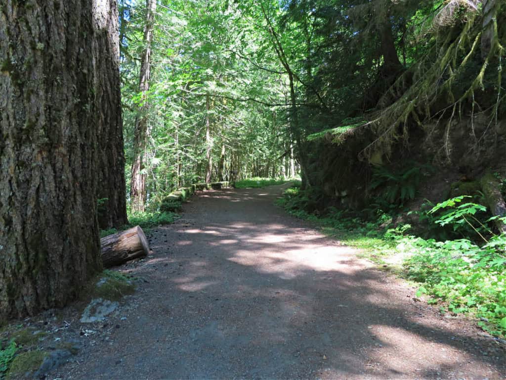
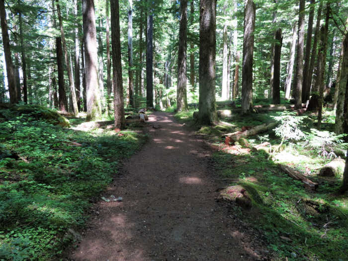
The second part of the river trail goes through beautiful large stands of old-growth forest including Douglas Fir, Western Red Cedar, and Western Hemlock making for a great hike through the forest.
There are other trails that the Silver Falls Trail connects to so keep an eye out for trail signs so you do not get on the wrong trail.
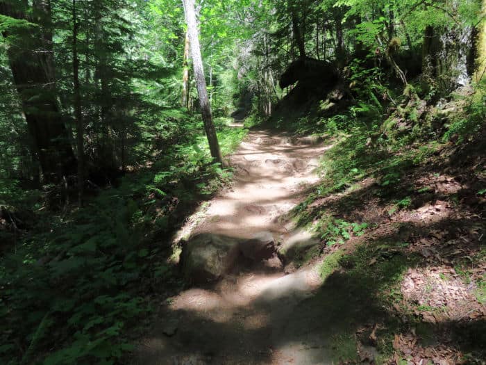
Silver Falls Loop Trail has some rigid inclines. It also includes many rocky spots and places with exposed roots.
Trail Safety
Always keep an eye for wildlife while walking this trail. Bears, deer, and other wildlife live inside of Mt. Rainier so it is possible to run into one.
Always practice bear safety including making noise when hiking, don't hike alone, and carrying bear spray if possible. Make sure to watch your step since this trail is uneven in many places.
Stay off of the moss-covered rocks by the falls! They are extremely slippery and visitors have lost their lives on them, please do not risk your personal safety!
What to bring?
Water: you will need water to prevent dehydration. Always carry the Ten Essentials for Outdoor Survival with you when you are going for a hike outdoors.
Hiking poles: Hiking poles help reduce stress off of your joints like your knees when you hike the inclines on this hike. Hiking poles also give you extra stability whenever walking in poor trail conditions like around trails that can have moisture/mist on them like from waterfalls as rocks, sticks, etc. become very slippery when wet.
Nearby Attractions
There are several nearby attractions to Silver Falls and Ohanapecosh. First and foremost, make sure to hike the Grove of the Patriarchs! also if you have time, make sure to drive up to Tipsoo Lake. This short loop trail has incredible wildflowers in the summer as well as breathtaking views of Mount Rainier, something you can't see from the Silver Falls Trail.
The Sunrise area of Mount Rainier has spectacular views of the mountain, a campground, a visitor center, and several hiking trails to explore!
Paradise is a visitor favorite! There are beautiful views along the way from Ohanapecosh, especially Reflection Lake. My experience has been that the best time to see the reflection is early morning, so set your alarm and arrive early! Trust me, it's worth getting up for.
Additional Mount Rainier Resources
Mt Rainier National Park Lodging
There are two National Park Lodges located within the park.
⭐️ 4.3 of 5 Stars - National Park Inn - Click here for Rates and Availability.
Mount Rainier National Park is home to the historic National Park Inn located at Longmire (Open year-Round), which was built in 1907.
The National Park Inn was built across the road from James Longmire's hot springs hotel. There is also a general store there located in a vintage 1911 log cabin.
⭐️ 4.3 of 5 Stars - Paradise Inn - Click here for Rates and Availability.
This lodge is so grand that it has been designated as a National Historic Landmark and placed on the National Register of Historic Places. The Paradise Inn is open from mid-May to October only.
Lodging near Mount Rainier
Depending on what you want to see and explore in Mount Rainier may determine where you will want to stay. I have broken down lodging between the three main park entrances for your convience.
Nisqually Entrance (Near the Longmire and Paradise areas of Mount Rainier)
⭐️ 4.3 of 5 Stars - Alexander's Lodge - Click here for Rates and Availability.
A charming historic lodge built in 1912, just 2 miles from the Nisqually Entrance to Mount Rainier National Park! This beloved inn sits on a stunning property with a trout pond, lush grounds, and a warm mountain-lodge vibe that hikers and park visitors return to year after year. Guests enjoy cozy rooms and suites with mountain character, a complimentary grab-and-go breakfast, free WiFi, free parking, and common areas perfect for unwinding after a long day on the trails. The location makes early morning park access incredibly convenient, letting you beat the crowds to Paradise and the Skyline Trail.
⭐️ 3.8 of 5 Stars - Nisqually Lodge - Click here for Rates and Availability.
Located 5 miles from the Nisqually Entrance,the lodge offers 24 spacious rooms with flat-screen TVs, WiFi, mini-fridges, microwaves, and Keurig coffeemakers, with free parking and children under 12 staying free. A great room with cathedral ceilings and an impressive stone fireplace greets guests on arrival, along with a computer station in the lobby and complimentary coffee available all day. Pet friendly rooms available, an outdoor fire pit, and laundry facilities on site. A great no-fuss base camp for snowshoers in winter and hikers and wildflower chasers in summer.
North Entrance (near the Sunrise Area of Mount Rainier)
⭐️ 4.0 of 5 Stars - Crystal Mountain Hotels - Click here for Rates and Availability.
The ultimate adventure basecamp, tucked at the base of Washington's largest ski resort just 6 miles from Mount Rainier National Park! In summer, step outside for scenic gondola rides, mountain biking, horseback trail rides, disc golf, and 35 miles of hiking trails right outside the door, with epic views of Mount Rainier from the summit. In winter it's ski-in/ski-out straight from your room. The Alpine Inn is the signature Bavarian-style hotel connected to the Alpine Inn Restaurant and the legendary Snorting Elk Cellar, while the Village Inn offers flat-screen TVs, mini-fridges, coffee makers, and WiFi for a more modern stay. The Summit House Restaurant at 6,782 feet is Washington's highest elevation restaurant, accessible by the Mt. Rainier Gondola with sweeping views of the Cascades.
South Entrance (Near the Ohanapecosh area of Mount Rainier)
⭐️ 4.2 of 5 Stars - Packwood Lodge and Cabins - Click here for Rates and Availability.
The nearest Packwood hotel to both Mount Rainier and White Pass, just 4 miles from the Stevens Canyon Entrance to the park! The renovated lodge offers 21 updated guest rooms and suites plus 9 detached mountain cabins, all uniquely designed and decorated.
⭐️ 4.3 of 5 Stars - Cowlitz River Lodge - Click here for Rates and Availability.
A clean, well-priced 32- room lodge in the heart of Packwood with one of the best perks around, elk grazing right on the front lawn! The lodge has a cozy stone fireplace in the lobby to warm up by after a day on the trails. A full hot breakfast is served each morning with waffles, eggs, biscuits and gravy, pastries, sausage, and a full beverage bar including hot apple cider. Free parking, laundry facilities, and pet friendly rooms available. Open year-round
Click on this link or the map below to see additional hotels and vacation rentals near Mount Rainier National Park.
Fun and educational Tours at Mount Rainier National Park
Mt. Rainier National Park Day Tour from Seattle
⭐️ Rating: 5 out of 5 Stars | ⏳ Tour Length: 10-12 hours | 🚌Check Rates and Availability
Experience the natural beauty of majestic Mount Rainier on this guided, full-day tour from Seattle. Enjoy a scenic, narrated journey past lakes, waterfalls, and historic towns to Mount Rainier. Take in spectacular views of Narda Falls, considered the most popular waterfall in Mount Rainier National Park and the aptly named Paradise.
Mt. Rainier Tour and Guided Hike
⭐️ Rating: 4.9 out of 5 Stars | ⏳ Tour Length: 10-11 hours | 🥾Check Rates and Availability
Explore the highlights of Mount Rainier on this day tour filled with glaciers, waterfalls, lakes, and old-growth forests. This tour departs from Seattle and includes a stop at Paradise, where you will get to hike from the visitor center at Paradise one mile to a picnic next to giant glaciers. You will also see Reflection Lake, Narda Falls, and Christine Falls. In the winter-spring, you will snowshoe rather than hike.
Mount Rainier National Park Self-Guided Audio Tour
⭐️ Rating: 5 out of 5 Stars | ⏳ Tour Length: 8-9 hours | 🔊Check Rates and Availability
Mount Rainier National Park is centered around an awe-inspiring, iconic volcano- Mount Rainier - and takes you through miles and miles of old-growth forest. The overlooks along the drive will take your breath away and the serpentine roads heading up to Paradise and Sunrise - the most popular sections of the park - will keep your heart pumping and your camera clicking. You can explore the stunning alpine meadows of Paradise, wander through the ancient forest of the Grove of the Patriarchs, and see impressive waterfalls.
Mount Rainier National Park Entrance Fee
Park entrance fees are separate from camping and lodging fees.
Park Entrance Pass - $30.00 Per private vehicle (valid for 1-7 days from the date of purchase)
Park Entrance Pass - Motorcycle - $25.00 Per motorcycle (valid for 1-7 days from the date of purchase)
Per-Person Entrance Pass - $15.00 Visitors 16 years or older who enter on foot, bicycle, or as part of an organized group not involved in a commercial tour.
Annual Park Entrance Pass - $55.00, Admits pass holder and all passengers in a non-commercial vehicle. Valid for one year from the month of purchase.
$30.00 for Commercial Sedan with 1-6 seats and non-commercial groups (16+ persons)
$75.00 for Commercial Van with 7-15 seats
$100.00 for Commercial Mini-Bus with 16-25 seats
$200.00 for Commercial Motor Coach with 26+ seats
Learn more about National Park Passes for parks that have an entrance fee.
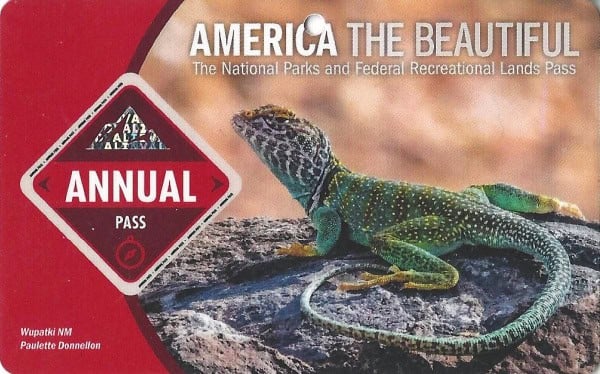
$80.00 - For the America the Beautiful/National Park Pass. The pass covers entrance fees to all US National Park Sites and over 2,000 Federal Recreation Fee Sites for an entire year and covers everyone in the car for per-vehicle sites and up to 4 adults for per-person sites.
Buy your pass at this link, and REI will donate 10% of pass proceeds to the National Forest Foundation, National Park Foundation, and the U.S. Endowment for Forestry & Communities.
National Park Free Entrance Days -Mark your calendars with the free entrance days the National Park Service offers for US citizens and residents.
Campgrounds in Mount Rainier
Campgrounds near Mount Rainier
- La Wis Wis Campground - Just outside Mount Rainier National Park near Ohanapecosh
Check out all of the National Parks in Washington along with neighboring Oregon National Parks, and Idaho National Parks.
Make sure to follow Park Ranger John on Facebook, Instagram, Pinterest, and TikTok

Leave a Reply